CHAPTER 1
EXTENT AND NATURE OF THE FRINGING MARSHES
1.1 INTRODUCTION
Wetlands are important for a number of reasons, and can be
evaluated in as many ways - for example, their role as bird habitats, in stabilizing
shorelines, as scenic attractions, and in nutrient exchange and primary productivity.
This study is concerned with one aspect, the possibility that the fringing wetlands
of the Peel-Harvey Estuarine System are important to the nutrient relations
of the open water. It is therefore concerned with the general extent of the
vegetation, with its approximate nitrogen and phosphorus content, and by using
published data, with providing some estimate of the rate at which the nutrients
may 'turn over' each year as plants grow and senesce. Attention is also given
to the frequency with which these fringing marshes are flooded, as such inundation
would provide an important mechanism for nutrient exchange with the open water.
Backshall (1977)
examined the peripheral vegetation of the Peel-Harvey system, including the
fringing marshes dealt with here, using a phytosociological approach of the
Braun-Blanquet type. The vegetation units he obtained were then ordinated using
Principal Axes Ordination, and the ordination overlayed with environmental data.
From this analysis he concluded that changes in salinity, elevation and soil
profile development most clearly accounted for gradient trends. The work described
below does not attempt to extend Backshall's observations on species associations
and their relationships with environmental variables, but is concerned with
grosser aspects of the amount of marsh vegetation and the nutrients which it
may contain and exchange.
1.2 MATERIALS AND METHODS
(a) The General Extent of the Wetlands
This was determined using colour aerial photographs, which
were examined for changes in elevation and vegetation type. A map was produced
and checked by ground inspection, particularly where the larger areas of marsh
were concerned. The extent of the marsh vegetation was also examined for Goegerup
Lakes.
(b) Floristics:
Throughout the study specimens were collected and pressed.
Identification was performed using the University of Western Australia Herbarium,
and Blackall and Grieve (1974).
Voucher specimens of many of the more common plants have been lodged with the
University of Western Australia Herbarium.
1.3 RESULTS AND DISCUSSION
(a) Area and Distribution of Marsh: The extent
of the marshes is summarised in Figure 1.1. From this
and more detailed inspections of aerial photographs, the area of the wetlands
likely to be involved was calculated to be 12.8 km2. This can be
compared with the surface area of the open water of the estuary, 115 km2.
If we consider the marshes and open water as an integrated system (total area
1282 km), the marshes represent 10% of the whole.
(b) Composition of Marsh Vegetation: A comprehensive
list of species is presented by Backshall
(1977). The present study commenced after the major flowering season, and
there are no additions to be made to Backshall's list.
The vegetation consists of a complex mosaic which cannot be
sensibly described in detail without resorting to a phytosociological analysis
of the type used by Backshall (1977),
concerned with the suites of species which most commonly occur together. Nevertheless,
we can point out some major components:
(i) Sarcocornia marsh: This is the most extensive
type of marsh, and is dominated by Sarcocornia blackiana. (The generic
name Salicornia has been used in the past, but the taxonomy has recently
been revised by Wilson, 1980).
It occurs in most localities where relief is low. Where it
occurs away from the waters edge, the lowest areas, which often have salt crystals
on the soil surface, are dominated by Arthrocnemum halocnemoides. Closer
to the waters edge Atriplex paludosa and Suaeda australis are
found in association with the Sarcocornia. The most extensive areas of
Sarcocornia marsh occur along the eastern edge of the Peel Inlet between
Fauntleroy and Greenlands Drains, and at the southern end of the Harvey Estuary.
(ii) Scirpus maritimus: Scirpus maritimus
grows in many places along the eastern shores of the Peel-Harvey system. There
is usually only a thin zone, possibly attributable to recent invasion by water-borne
corms. There are large Scirpus maritimus meadows at the southern end
of the Harvey Estuary, which extend from the present waterline to the extensive
Sarcocornia marshes behind, and appear to cover an area once dominated
by Juncus kraussii. Some very small islands, close to the waters edge,
are still dominated by J. kraussii in this area.
(iii) Juncus kraussii: Pure strands of J.
krausii do not occur as extensive meadows. There are small meadows of this
species near the Yunderup Canals, just south of Boggy Bay and in other places
along the south-eastern Harvey estuary. J. kraussii occurs with a patchy
distribution around most of the estuary, often as a thin discontinuous zone
which is only three or four clumps wide.
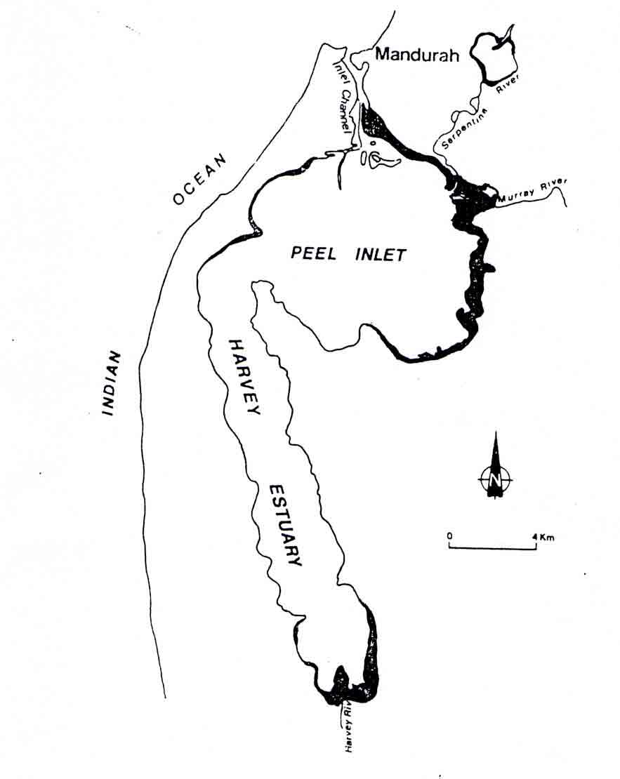
Figure 1.1: Marsh vegetation
of the Peel-Harvey System: Much of the waters edge carries a thin fringe
of marsh; more extensive areas are shown in black.

